Drought monitoring and operations
Interstate Commission on the Potomac River Basin
Jump to: Status | Preparation | Monitoring and Operations

USGS stream gage on the Potomac River at Point of Rocks, Maryland.
During periods of drought, the Cooperative Water Supply Operations on the Potomac (CO-OP) helps manage the Washington metropolitan area water supply system by coordinating withdrawals from the Potomac River and off-river reservoirs and recommending releases from upstream reservoirs when forecasted flow in the river is not sufficient to meet expected needs. These needs include water demands and an environmental flow-by of 100 million gallons per day (MGD) on the Potomac River at Little Falls dam near Washington, D.C. Learn more about CO-OP’s work on the CO-OP History page.
Drought Management Status: Not active
During active Drought Management the updates are available on the CO-OP Data Portal each morning and afternoon.
Drought Monitoring and Operations
CO-OP begins daily Drought Monitoring when flow at the U.S. Geological Survey (USGS) stream gage at Point of Rocks, Maryland, falls below 2,000 cubic feet per second. During Drought Monitoring, CO-OP sends out daily email reports to stakeholders summarizing flow, weather, and demand conditions. These monitoring updates are made available each morning on the CO-OP Data Portal.
CO-OP begins Drought Operations when flow in the Potomac River at the U.S. Geological Survey gage at Little Falls dam drops below the total metropolitan area supplier daily Potomac River withdrawals plus the 100 million gallons per day flow-by, or when CO-OP flow forecasts indicate that there is a significant chance that releases from Jennings Randolph and/or Little Seneca reservoirs will be needed within the next ten days. During Drought Operations, CO-OP sends out reports to stakeholders twice daily. Reports summarize basin flow conditions, system demands, and reservoir storage volumes. They contain recommended withdrawal targets and reservoir release rates. These reports are made available to the public through the CO-OP Data Portal.
USGS Gage: Potomac River at Point of Rocks, MD
The Potomac River at Point of Rocks gage is cooperatively operated by ICPRB, USGS, and the Metropolitan Council of Governments.
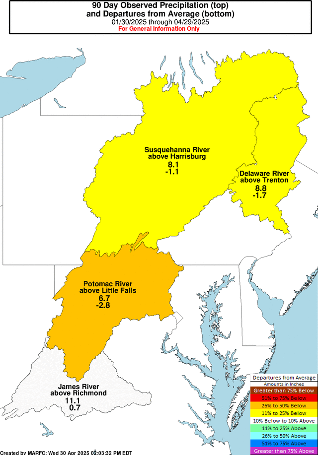
Middle Atlantic River Forecast Center’s Observed Precipitation
The following map is just one of the many tools that CO-OP staff use to monitor the drought status:
Drought Preparation
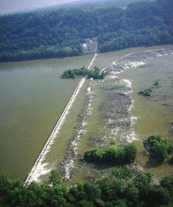
Potomac River at Little Falls dam near Washington, D.C.
Annual drought exercises are conducted by the CO-OP with stakeholders to ensure a cohesive, coordinated response in the event of a low flow on the Potomac River.
The Water Supply Outlook is published by CO-OP staff on a monthly basis between April and October of each year. It provides an update on the possibility of water supply releases from the area’s reservoirs based on long-term precipitation data, flows, and other information for the Potomac basin.