Potomac Estuary
Interstate Commission on the Potomac River Basin
Where Fresh Water Meets Salt Water
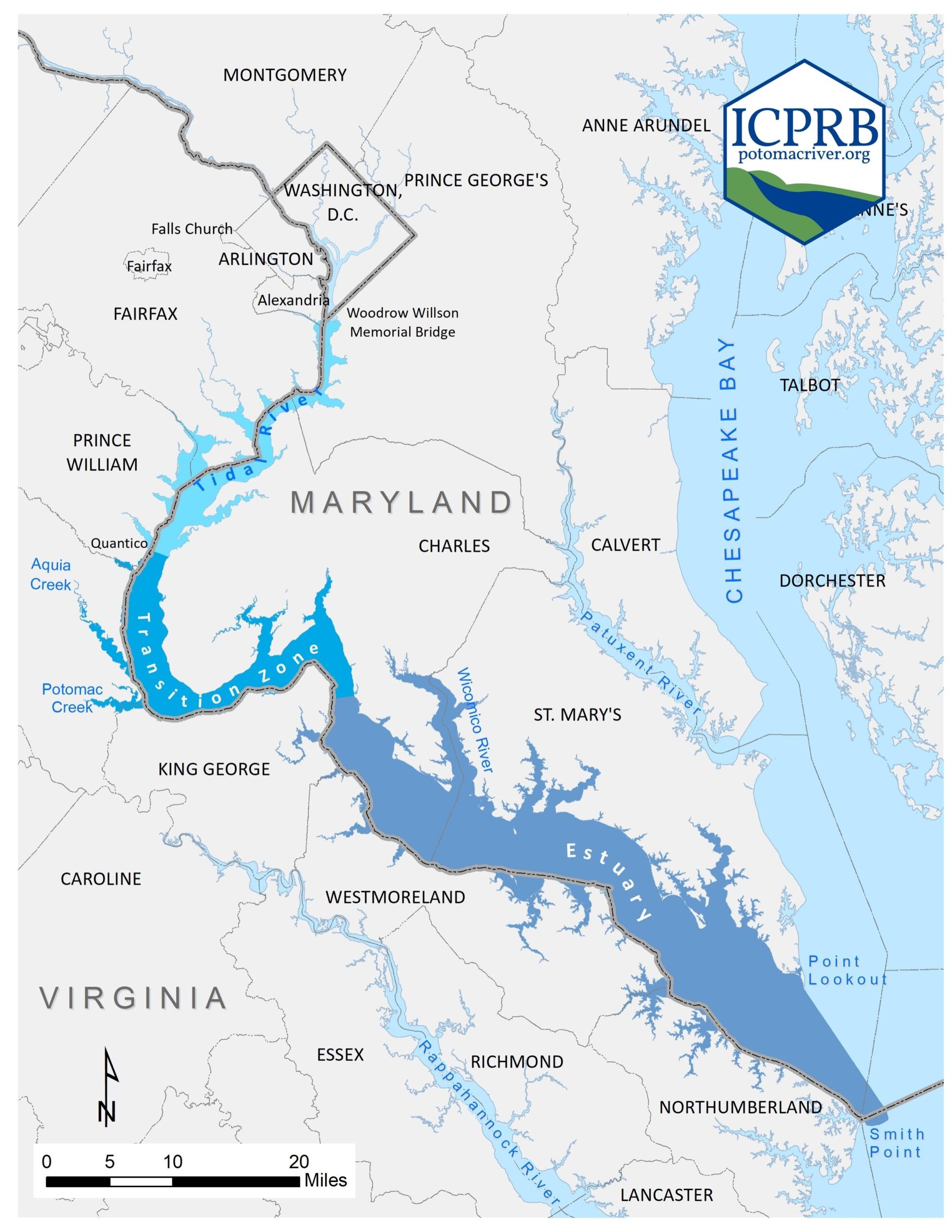 Rising sea levels at the end of the Pleistocene glaciation “drowned” the Potomac River valley below the Piedmont fall-line, forming the river’s 113 mile (182 km) long estuary. An estuary is where the ocean tides meet the river.
The estuary’s favorable topography once supported one of the most productive fisheries in eastern North America.
- Integrative Analyses: Holistic studies of the Potomac River estuary.
- Phytoplankton Nutrient Limitation: Researchers used previous collected nutrient bioassay results to develop a model that predicts nutrient limitation in surface waters of the Chesapeake Bay mainstem.
- Water Quality Binning Method: The water quality binning method reveals a favorable phytoplankton state is distinguished in multiple ways from an adverse, undesirable state.
- Larval Striped Bass Habitat Index: The index provides an indicator of the quality and potential of each Chesapeake Bay tributary’s striped bass spawning and nursery habitat for each year of available data.

Phytoplankton Nutrient Limitation
Nutrient bioassays of Chesapeake Bay phytoplankton conducted between 1992 and 2002 showed that nutrient concentrations below ~0.07 mg/L dissolved inorganic nitrogen as N or below ~0.007 mg/L orthophosphate as P were able to limit the formation of algal blooms (Fisher and Gustafson, 2003, 2005; Fisher et al., 1999). These nutrient thresholds were used in combination with season- and salinity-dependent Secchi depth thresholds to characterize reference conditions for estuarine phytoplankton (see Water Quality Binning Method).
In 2020, a team of researchers used these bioassay results to model the temporal and spatial distribution of nutrient limitation in Chesapeake Bay. Researchers then applied the model to water quality data from the long-term, fixed-site monitoring program (1990 – 2017) to characterize nutrient limitation on much broader geographic and temporal scales than would be feasible using bioassays.
Modest changes in nutrient limitation patterns have occurred, with expanded areas of nitrogen-limitation and contracted areas of nutrient saturation (i.e., not limited by nitrogen or phosphorus). These changes imply that long-term reductions in nitrogen load have led to expanded areas with nutrient-limited phytoplankton growth in the Bay, reflecting long-term water-quality improvements in the context of nutrient enrichment. However, nutrient limitac tion patterns remain unchanged in the majority of the mainstem, suggesting that nutrient loads should be further reduced to achieve a less nutrient-saturated ecosystem.
Zhang, Q., T. R. Fisher, E. M. Trentacoste, C. Buchanan, A. B Gustafson, R. Karrh, R. R. Murphy, J. Keisman, C. Wu, R. Tian, J. M. Testa, and P. J. Tango. 2021. Nutrient limitation of phytoplankton in Chesapeake Bay: Development of an empirical approach for water-quality management. Water Research 188 (2021) 116407. https://doi.org/10.1016/j.watres.2020.116407.
Water Quality Binning Method
The strong phytoplankton responses to the water quality categories created with the binning method confirms the forceful influence of light and nutrients on phytoplankton. Favorable and adverse states of the phytoplankton community are apparent, separated primarily by water clarity (light). In the absence of phytoplankton samples, when only water quality data are collected, these categories can be used to infer important aspects of phytoplankton community structure (e.g., taxonomic composition, biomass) and function (e.g., light adaptation, net oxygen production, exudation). In the tidal waters of Chesapeake Bay, water clarity thresholds separating the two states are Secchi depths of 0.7 – 0.9 meters in shallow, well-mixed, low salinity waters and 1.2 – 2.1 meters in deeper, stratified, higher salinity waters. Nutrient limitation thresholds for estuarine phytoplankton were empirically determined in earlier bioassay studies and are ~0.007 mg PO4-P/L and ~0.07 mg DIN-N/L (Fisher and Gustafson, 2003, 2005; Fisher et al., 1999).
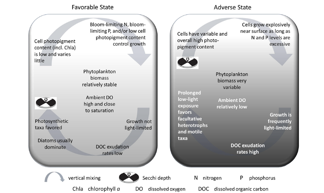
Conceptual diagram of alternate states for phytoplankton in the
estuarine surface mixed layer (from Buchanan 2020).
Buchanan, C. 2020. A water quality binning method to infer phytoplankton community structure and function. Estuaries and Coasts 43(4):661-679. https://doi.org/10.1007/s12237-020-00714-3.
The water quality binning approach also seems to work as well in three Maryland reservoirs, separating phytoplankton into favorable and adverse states. Elevated phytoplankton levels (Chla greater than 10 µg/L) were avoided when nutrient concentrations were below 0.03 TP mg/L and 0.07 TN mg/L and Secchi depth was greater than 5.5 m.
Algal Blooms in the Baltimore, Maryland USA Reservoirs and Their Relationship to Water Quality Category (ICPRB Report 05-3)
The environmental condition categories created with the water quality binning method strongly resemble the disturbance gradients (level of exposure to combined stressors) used to develop Biological Condition Gradients.
Larval Striped Bass Habitat Index
A habitat index derived from water quality and zooplankton monitoring data was developed to assess the suitability of annual environmental conditions for larval striped bass recruitment in three Chesapeake Bay tidal tributaries (Potomac, Patuxent, Choptank). The habitat index corresponds strongly with the Maryland juvenile striped bass index which is a measure of recruitment success.
A Larval Striped Bass Habitat Index (LSBHI) for Chesapeake Bay Tributaries (ICPRB Report 03-1)
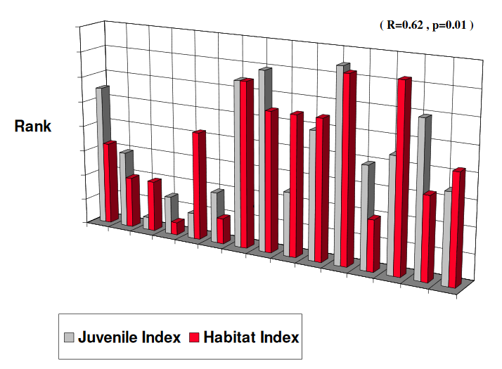
Spearman’ s rank correlation for the Potomac juvenile striped bass from the Maryland Beach Seine Survey with the LSBHI values calculated using the Chesapeake Bay Program monitoring data.
Return to Aquatic Life Main Page