Mike Nardolilli, ICPRB Executive Directors, shares information on ICPRB’s work on source water protection.
In celebration of the inaugural Source Water Protection Week, the Interstate Commission on the Potomac River Basin gathered videos and news from organizations who work hard to protect our drinking water.
Nikki Bellezza of Fairfax Water shares information on their Water Supply Stakeholder Outreach Grant Program.
In celebration of the inaugural Source Water Protection Week, the Interstate Commission on the Potomac River Basin gathered videos and news from organizations who work hard to protect our drinking water.
In celebration of the inaugural Source Water Protection Week, the Interstate Commission on the Potomac River Basin gathered videos and news from organizations who work hard to protect our drinking water.
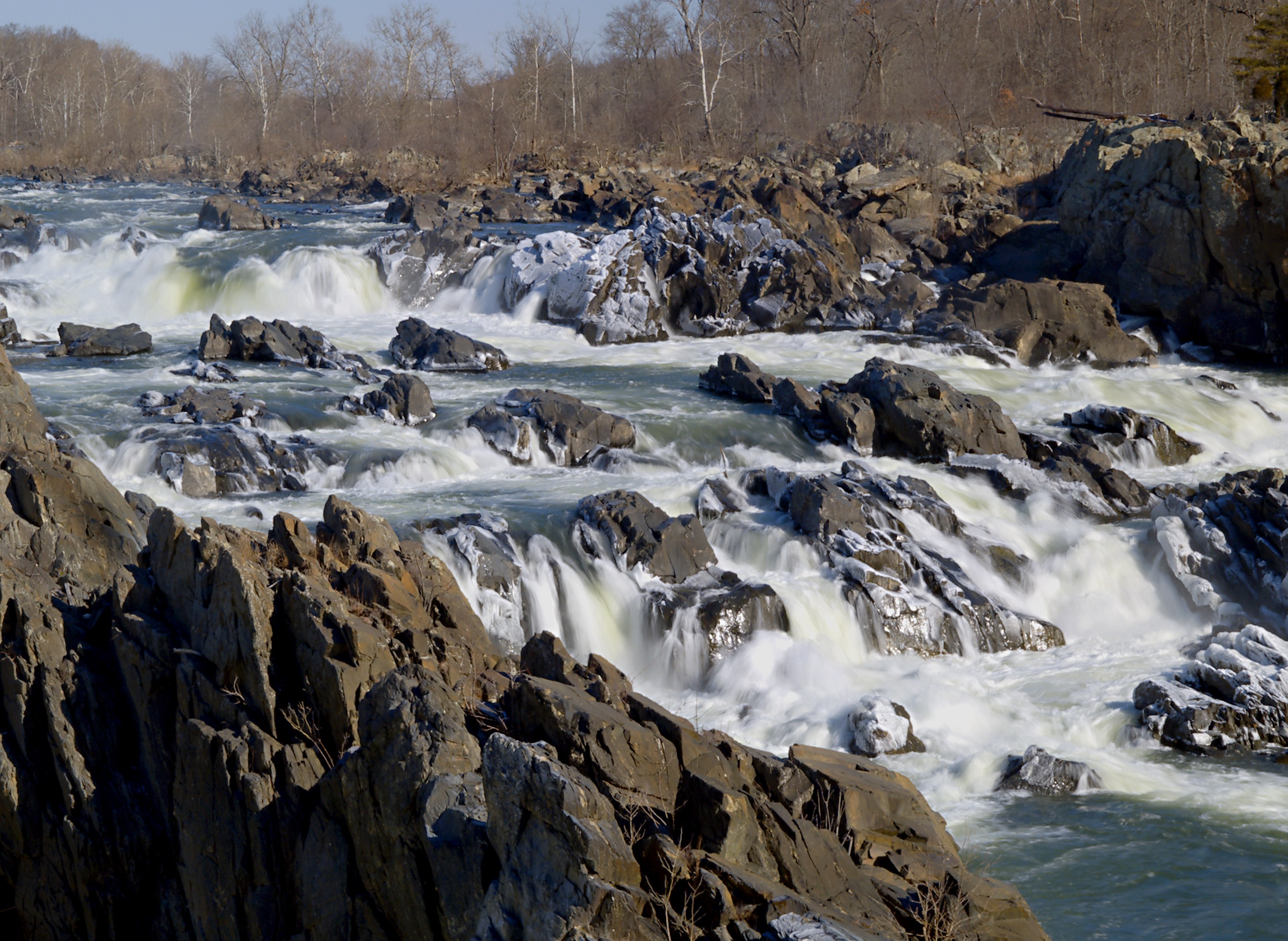
The dramatic rocky rapids of Great Falls provide the perfect background for yesterday’s history and today’s selfies. Two National Parks flank both sides of the Potomac at Great Falls: (1) Great Falls Park on the Virginia side; and (2) the C&O Canal National Historical Park on the Maryland side.
According to archaeological records, this area has been a meeting place for thousands of years. The Piscataway and Powhatan tribes used the area for trading missions from 8000-1700 BC. Much of the modern history of the area involves the boom-and-bust cycle of towns built around one industry: the construction of the canal. The ruins of one such town, Matildaville which was named after the mother of Robert E. Lee, are still visible today.
Starting in the early 1800s, city folk would venture up the river via a 6 to 8-hour boat ride to eat, dance, and spend a mere $.25 to stay the night at the lodge. A carousel, installed in 1906, was a big draw for the Great Falls Amusement Park. The amusement park closed in 1952 but the carousel stuck around until Hurricane Agnes blew through and destroyed it in 1972.
Today, getting to the falls is much more convenient. Whether accessed from the Virginia or Maryland side, the falls are possibly the most photographed section of the Potomac River. As one of the more popular parks in the area, the riverside retreat is still a popular meeting place and can get crowded on nice days. Both sides of the river have visitor’s center with maps and history of the area and picnic tables to enjoy an alfresco meal.
On the Maryland side, visitors can get a small taste of the history by taking a boat ride through the 8-foot rise of the canal while park attendants, dressed in period costumes, tell the story of the area.
The falls are a natural boundary between the navigable tidal Potomac below and the river’s freshwater mainstem above, thwarting those who travel by water. This holds true for both humans and aquatic species, as this area is the natural upstream boundary of the American shad migration.
The variety of hiking levels go from “Easy Stroll” to “Mountain Goat-Inspired.” If you are of the mountain goat-variety hiker, check out the 1.7-mile Section A of the Billy Goat Trail. Make sure to bring water, snacks, sunscreen, and a map, as the short distance can be deceivingly hard, especially on warm days.
The rapids are for admiring, not for swimming or wading. It is dangerous and illegal to swim anywhere in Great Falls. The 15-mile Potomac River Gorge can create unexpected treacherous conditions even for the most skilled swimmers and paddlers.
Always check Current Park Conditions before visiting the park as trails or other areas of interest could be closed.
Looking for someplace new to visit in the Potomac basin? The weekly About the Basin feature highlighting destinations (on our Facebook, Twitter, and Potomac River Watch) are now available on the Wandering the Watershed map. Readers can now choose a destination from our compiled list of basin gems. Visit regularly as new postings will be added. Enjoy your tour through the Potomac basin! The new feature also can be accessed through the maps page on our website.
The Interstate Commission on the Potomac River Basin Welcomes new Pennsylvania Alternate Commissioner Kristina Peacock-Jones. Peacock-Jones serves the Commonwealth as a Program Manager in the Compacts and Commissions Office at the Pennsylvania Department of Environmental Protection (DEP) and serves as the Commonwealth Drought Coordinator.
She manages the State Water Plan and Coastal Resources Management Program Sections and has experience with various grant programs. She began working at DEP seven years ago in the Bureau of Safe Drinking Water as the Environmental Group Manager of the Source Protection and Allocation Section. Previously, Peacock-Jones worked as an environmental and civil engineering consultant in Pennsylvania, Maryland, and New Jersey. She has bachelor’s and master’s degrees in Environmental Engineering from Drexel University and is a licensed professional engineer in Pennsylvania.
Peacock-Jones serves as an alternate to ICPRB Pennsylvania Commissioner Patrick McDonell, the DEP secretary. She replaces Summer Kunkel, also a DEP staff member.
Peacock-Jones’ wealth of background and experience make her a valuable new member of ICPRB, and we welcome her aboard.
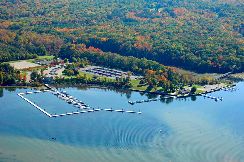
Smallwood State Park in southern Maryland offers a variety of activities alongside a picturesque view of Mattawoman Creek, a tributary of the tidal Potomac River.
The area was the ancestral land of the Piscataway Conoy tribe. Eventually the land became a thriving tobacco plantation as part of a large tract of land known as the Mattawoman Plantation. The park is named after General William Smallwood, who was born and raised on the plantation in the 1700s. He was both a decorated soldier in the American Revolution and a popular politician in the Maryland assembly. Smallwood’s economic success was built on the backs of the 56 enslaved people who lived on the property during his time. Many worked as field hands, vegetable gardeners, blacksmiths, and carpenters.
The Smallwood Retreat House, built in 1760, was used as a respite from Smallwood’s aristocratic life as a politician and military-man. In 1792, Smallwood passed away without heirs. The house and land eventually fell into disrepair. In the 1930s a group of enthusiastic locals organized the restoration and put the gears in motion for the area to eventually become Smallwood State Park in 1957.
Tours of the restored Retreat House and the 19th century tobacco barn are available. A Colonial Christmas open house, showcasing historically accurate holiday decorations, is held each December.
At only 628-acres, the Smallwood State Park as an impressive variety of activities. Birding, especially for waterfowl, is a popular activity due to the wide variety of species to see and hear. However, you will want your binoculars in one hand and your fishing pole in the other. Anglers rave about the fish caught from the piers along Sweden Point Marina (please follow local licensing requirements). The park is the launch location of several fishing tournaments.
At only 2 miles of trails, the hiking opportunities in the park are short but beautiful. Want to go further? Jump onto a section of the Potomac Heritage National Scenic Trail which runs alongside the park. This 710-mile trail follows the Potomac River while highlighting historical and cultural features along the way.
The Mattawoman Creek Art Center within the park features local as well as up-and-coming artists. The center provides several art shows throughout the year showcasing a variety of fine art pieces.
A campground offers 8 rustic cabins and 15 tent and RV-friendly campsites. There is a playground, picnic area and pavilions.
With quick and easy access to the Potomac River, the Sweden Point Marina is a popular place to launch boats.
If you can’t make it down to southern Maryland, you can still enjoy the view with the Smallwood State Park Osprey Cam. The birds are most active late-spring through early-summer, but the camera provides a nice view of the river all year long.
Looking for someplace new to visit in the Potomac basin? The weekly About the Basin feature highlighting destinations (on our Facebook, Twitter, and Potomac River Watch) are now available on the Wandering the Watershed map. Readers can now choose a destination from our compiled list of basin gems. Visit regularly as new postings will be added. Enjoy your tour through the Potomac basin! The new feature also can be accessed through the maps page on our website.
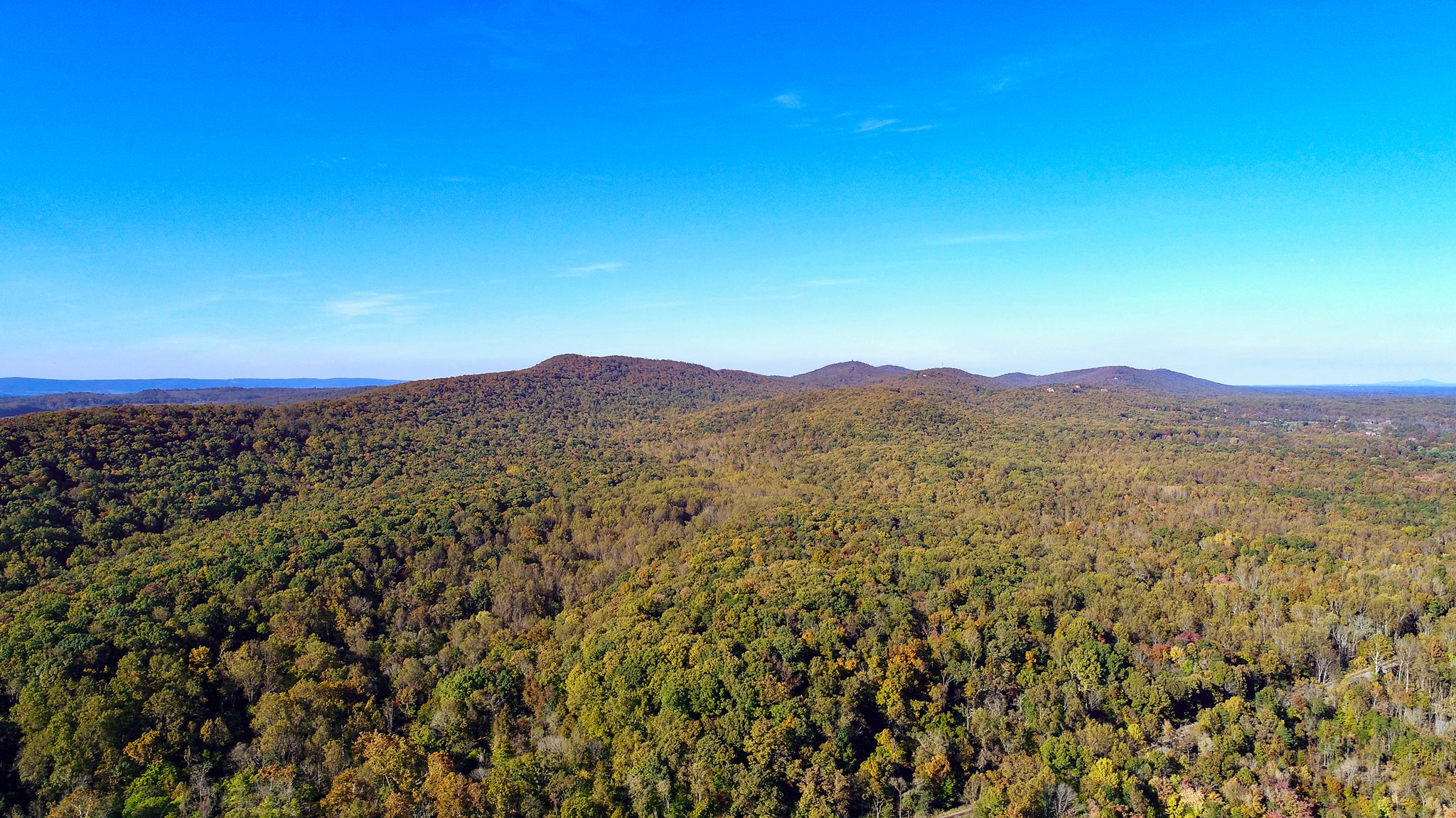
The Bull Run Mountains Natural Area Preserve is an outdoor living laboratory located only an hour drive from the D.C. Metro area. It is staffed with Natural Area Preserve managers who carefully oversee the 2,486 acres to preserve the impressive biodiversity and the unique forest and woodland communities found on the mountain.
Photo Credit: Virginia Outdoors Foundation
Since 2002, Bull Run has been owned and managed by the Virginia Outdoors Foundation (VOF) which was established to promote the preservation of open-space lands and to encourage private gifts of money, securities, land or other property to preserve the natural, scenic, historic, scientific, open-space and recreational areas of the Commonwealth. They protect 850,000 acres across Virginia.
In an effort to balance public use with the preservation of the natural ecosystem, the northern section has restricted access, and the southern section is only open to the public Fridays, Saturdays, and Sundays. The public can access the area by way of 7-miles of hiking trails, public programming, and volunteer opportunities. Grab a trail map to find the hikes that lead to picturesque views of the Blue Ridge mountains. A few simple rules apply during your visit: please stay on the designated trails, no dogs are allowed, and practice Leave No Trace principles. They also host school-aged children, university students, and researchers. There is an active stream restoration and monitoring program on site.
Cultural history is an important part of the VOF program. The area is part of the ancestral land of the Manahoac Indigenous people who practiced prescribed burning to create a wildlife habitat conducive for hunting. However, according to notes by the explorer John Smith, they did not burn the hills along Bull Run and throughout the Blue Ridge mountains. The VOF protects many regionally important cultural history sites on the land. Staff provide guided hikes with titles such as Black and African American History of the Preserve and a spooky Cemetery Night Hike. Volunteers are a vital part of the program, so if this sounds interesting, contact them to find out more.
Not too far from Bull Run Mountains Natural Area Preserve, the Bull Run Mountains Conservancy works to protect the region through education, research, and stewardship. They provide engagement opportunities throughout the year at nearby areas like Leopold’s Preserve. The Halloween Safari is an annual event at Leopold’s Preserve, which is a not-as-spooky-as-it-sounds nighttime hike followed by a bonfire and live music.
Contact these organizations to learn more about the recreation, education, and volunteer opportunities in the area.
The Interstate Commission on the Potomac River Basin (ICPRB) will hold its quarterly business meeting virtually on August 31, 2021.
The Section for Cooperative Water Supply Operations on the Potomac (CO-OP) will begin at 8:30 a.m. and will feature an update on efforts to increase supplemental storage for the metropolitan area water supply.
The ICPRB meeting will begin at 9:45 a.m. Commissioners will get an update on the Land Prioritization Project, which assists planners in targeting land conservation efforts that can benefit drinking water source quality and ongoing enhancements to spill modeling to protect drinking water and water quality from contamination. The commissioners also will receive a report on ICPRB’s evolving Justice, Equality, Diversity, and Inclusion policy.
Members of the public who wish to view the proceedings should send a request through our Contact Us page no later than close-of-business on August 26. You will be sent a link to the meeting.
Looking for adventure in the Potomac River basin? Over the years we have covered many cultural, historical, and recreational sites in our weekly About the Basin posts (through social media and our website). All the points of interest are now conveniently located on a StoryMap!
Take a moment to check out the website to wander the watershed and explore the many interesting places the basin has to offer. Future stories will be added as they are published.
The history of the 400-acre East Potomac Park is a good reminder of what we can accomplish through ingenuity, creativity, and a little extra dirt.
The park is on the District side of the Potomac River just north of the confluence with Anacostia River. Prior to the late 1800s, this area was mostly underwater, with muddy flats only appearing during low tide. At the time the city was struggling with this stagnant, stinky, mosquito-infested, raw sewage-filled wasteland known as the Potomac Flats. The Army Corps of Engineers decided to dredge the river while using the dredged material to build an island and creating a shipping channel that would allow ships to reach downtown D.C. It was then that the engineering marvel of the Tidal Basin was developed to keep silt from building up in the channel.
Formalized as “Potomac Park” in 1897, from the beginning, the park was designated as a recreational area for the benefit of city residents. Many would escape the heat of the city to picnic, fish, or bike under the cool canopy of the trees along the river. It is still enjoyed by residents and is considered one of D.C.’s best kept secrets.
In 1917, soldier’s barracks were built and a portion of the land was turned into Victory Gardens by the Boy Scouts of America. Through the years there was a campground, a tea house, and horse stables.
In the 1960s, the park benefited from Lady Bird Johnson’s efforts to beautify the capital city. She planted many of the cherry trees along in the park that were gifted by the Japanese government. Additionally, she donated a charming floating fountain which was installed just off Hain’s Point at the southern end of the island. Unfortunately, the fountain was soon removed as it was deemed a public health hazard for spraying high levels of coliform onto the park.
Thankfully, spray from the river is no longer a public health threat. Many enjoy stand up paddleboarding, kayaking, and canoeing in the river, especially during the magical couple weeks in spring when the cherry blossoms are popping with color.
Golf courses (both mini and regular-sized), a pool, tennis courts, athletic fields, playgrounds, and picnic facilities provide plenty of opportunities to get outside and get active on this island with a rich, but short, history.
Photo Credit: H. Herrman
Newsletter Subscription
Stay informed about the latest news, impactful projects, environmental challenges, and community initiatives in the Potomac River watershed—sign up today!

 Formalized as “Potomac Park” in 1897, from the beginning, the park was designated as a recreational area for the benefit of city residents. Many would escape the heat of the city to picnic, fish, or bike under the cool canopy of the trees along the river. It is still enjoyed by residents and is considered one of D.C.’s best kept secrets.