News

Entry Thumbnail

About the Basin: Lost River State Park

Lost River State Park

About the Basin, July 23, 2021

Lost River State Park is an excellent choice for a weekend away from the DC Metropolitan area. It is only a 2.5-hour drive to the eastern panhandle of West Virginia but the park seems a world away.

Rock building with a view of the mountains in the background.

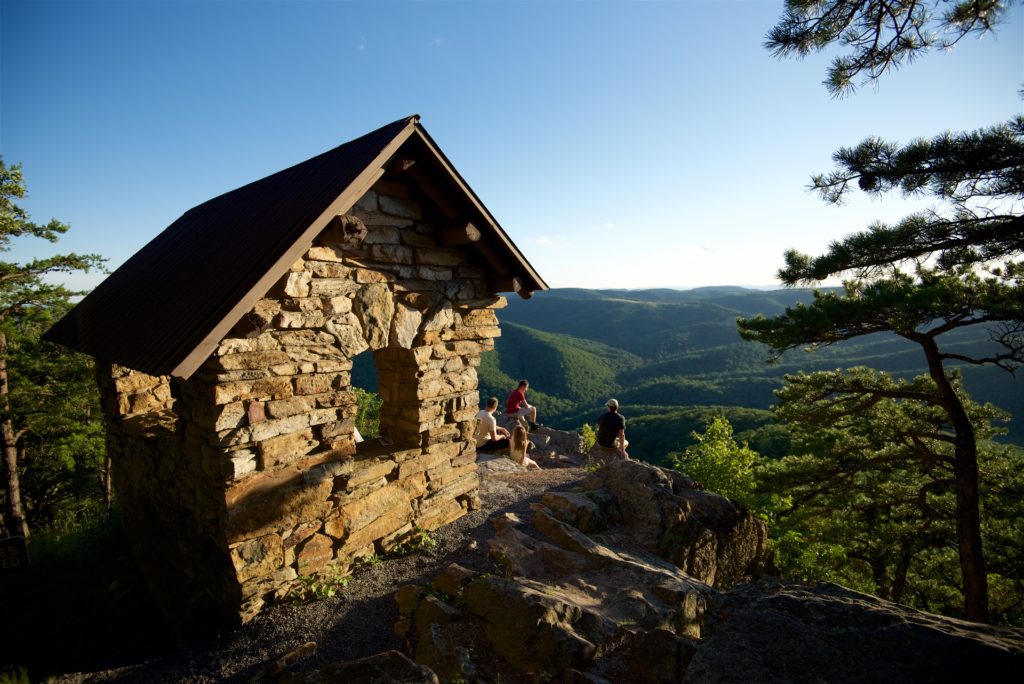
Cranny Crow Overlook. Photo Credit: WV State Parks

The namesake for the Lost River State Park is not, in fact, lost. The 31.1-mile river temporarily dips underground near McCauley, W.V. then reappears as the Cacapon River. Around 81 miles later, the Cacapon joins the Potomac River.

Whether you want an easy, kid-friendly stroll along a stream (Howard Lick Trail) or a rigorous climb with a breathtaking summit (Big Ridge Trail), there is a hike for everyone at Lost River State Park. Horses, bikes, and hikers are welcome along the trails. The most popular destination is the Cranny Crow overlook which offers a view of the surrounding 6 counties and two states.

Many visitors enjoy swimming and wading in the river on a hot summer day before enjoying a barbecue at one of the many picnic pavilions.

Several campsites are available, including 6 Tentrr sites. Tentrr are pre-set sturdy canvas tents placed on wooden platforms located throughout the park.

Canvas tent on the side of a creek surrounded by trees.

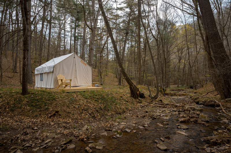
Tentrr along the creek. Photo Credit: WV State Parks

A unique hike-in cabin option, the Primitive Outpost Cabin, is available on top of the Big Ridge Mountain. With no electricity or running water, this is the perfect place to decompress from modern comforts next to a roaring fireplace. For a more luxurious stay, check out their 26 other cabins. These come equipped with water, electricity, and even Wi-Fi.

The land was originally the home of the Massawomeck tribe which was part of the Iroquois Native Americans. The area is part of the Fairfax Grant, the massive area of land promised to the allies of the then exiled English King Charles II as a last-ditch effort to hold onto to the throne. By 1719, Thomas Lord Fairfax had inherited much of the land. In 1756, the Battle of Lost River occurred during the French and Indian War.

After the Revolutionary War, the Fairfax Land Grant property was granted to American patriots. The father of General Robert E. Lee, Henry “Light-Horse Harry” Lee acquired property and built a summer cabin which has since become a museum in Lost River State Park. It is open weekends from Memorial Day to Labor Day.

Entry Thumbnail

In Full Bloom: McKee-Beshers Wildlife Management Area

You might think field upon field of bright yellow sunflowers are found only in provincial Italy or France and other places known for romance and beauty. But there are 2,000 acres right in our backyard that will make you feel transported to a more magical time and place. Known as the McKee-Beshers Wildlife Management Area (WMA), staff at this park plant acres of sunflowers to attract and feed pollinators and birds. For a couple weeks each year (around the end of July) the WMA is alight with seemingly endless summery flowers.

Flowers at McKee-Bashers Wildlife Management Area

Photo Credit: Instagram user @walkablefrederick

Just like birds, people flock to the area for family photos, nature photography, and just to enjoy the sites. Catch the flowers at full bloom over the next couple weeks. Meandering trails throughout the fields let you explore without damaging the flowers. However, look but don’t pick; plucking one of these beauties is prohibited at the WMA.

When the sunflowers aren’t the main attraction, there are plenty of trails to hike or bike in the area. Since they are connected to the C&O Canal trail system, the WMA trails makes for a nice side trip or starting point on the Canal. Hunting waterfowl, deer, wild turkey and other animals is allowed (within hunting regulations). There is even a specially managed dove field open to the public for hunting. Birding and wildlife photography are popular activities at the WMA due to the abundance of wildlife, including 200 species of songbirds found in the area. The more adventurous can take a boat across the Potomac to reach Maddux Island, which is part of the WMA.

A beautiful trail follows some of the perennial marshy flatlands where waterlilies and other aquatic plants abound. Parts of the WMA are managed as a greentree reservoir, a term used for bottomland hardwood forest that is flooded in the fall and winter. This attracts colorful migrating waterfowl, such as wood ducks.

The park, in western Montgomery County, Maryland, is conveniently located right off River Road. It is not difficult to find, just plug “McKee-Beshers Management Area” into your GPS and look for the parking lots full of cars and people in incongruously fancy dress for a hike. After all, this is a popular place to take family photos. There are several ways to access the fields, but most involve a short walk through the woods that is often muddy, so make sure to wear appropriate footwear. No bathroom facilities or benches are provided, so please plan accordingly.

Sunflowers blooming under a clear sky

Photo Credit: Instagram user @walkablefrederick

Entry Thumbnail

About the Basin: Prince William Forest Park

Prince William Forest Park

July 16, 2021

Looking for a “a drop-dead beautiful place” (Tripadvisor review, Oct. 2019) that is also a quiet respite from the activity of the big city and was once training ground for spies? That’s pretty specific, but we found it for you. Prince William Forest Park (PWFP) is located only 35 miles south of Washington, D.C. along the I-95 corridor. At 15,000-acres, it is the largest park in the National Park Service’s Washington Capital Region and one with an eventful past.

Young black boys receiving an archery lesson.

Archery Lesson. Credit: National
Park Service Museum Collection

Recreation

The park has 37 miles of hiking trails, rustic cabins, an RV campground, and primitive hike-in campsites. The park covers much of the Quantico Creek watershed with several streams and ponds for fishing and exploring.

Are you up for a navigational challenge? Grab a map and a compass from the visitor’s center to try your hand at orienteering. This Scandinavian sport uses a map and compass to navigate to various checkpoints throughout the forest. The park has 30 orienteering courses for all navigational skill levels. You will have a chance to practice your spy skills, like park residents of the past.

Park’s Past

Like many parks in the National Park Service, PWFP has a storied past. Prior to the Great Depression there were several well-populated African American communities in the area including Hickory Ridge and Batestown. These towns had been well established for hundreds of years. The towns grew after the Civil War as many formally enslaved people moved in and called it home. Many of the residents worked in the local Cabin Branch Pyrite Mine until the mine closed in 1920.

When the federal government instituted the Resettlement Administration (RA) program in 1935 to provide land to struggling farmers, they bought or condemned much of the property and forced the community out of their homes. Many residents resisted. The federal government continued to acquire land as part of the Recreational Demonstration Area program which claimed to protect forestland, provide jobs, and create recreational opportunities for nearby city-dwellers. This stretch of Eastern Piedmont forest would soon become the Chopawamsic Recreational Demonstration Area. It was thought to be a shining example of what the RA program could do. In 1948 the park was renamed Prince William Forest Park.

War-time Efforts

After the attack on Pearl Harbor, area residents who had not left by the 1940s were forcibly removed to make way for a training camp for the Office of Strategic Services (now known as the CIA). The Quantico Marine Corps Base abuts the park to the south. The park’s relationship with the base was fraught, but fruitful, for both parties. The military used the camp cabins, built by the Civilian Conservation Corps, to train spies and radio operators. There was even a “Little Tokyo” training facility. At one point, the park administrator convinced the military to build roads and other infrastructure in the park as part of their training operations. In honor of its war-time history, the park now holds a 3-day Spy Camp each summer.

A more detailed account of the park’s fascinating history can be found in Prince William Forest Park: An Administrative History.

A Visitor’s Center with maps and information is located at 18170 Park Entrance Road in Triangle, Virginia. The PWFP staff frequently update the COVID-19 operating status so please check online prior to heading out.

Entry Thumbnail

About the Basin: Buchanan State Forest

Buchanan State Forest

Looking for history, hiking, adventures, and a beautiful view in one easy stop? The Buchanan State Forest in south central Pennsylvania is the place to be. The land straddles the northern edge of the Potomac River basin. One side of the mountain range drains to the Potomac while the other side drains to the Susquehanna.

History

Boy riding into an abandoned tunnel. Lush vegetation on both sides of the trail.

Abandoned Pennsylvania Turnpike – Pike 2 Bike Trail

The 69,703-acres of dense forest contains ample United States history. This includes the remnants of a road used to supply British troops during the French and Indian War, a saltpeter mill used during the American Revolution, cemeteries from the antebellum era, and a CCC camp that housed conscientious objectors and German prisoners of war during World War II. The hometown of our 15th president, James Buchanan, is nearby at the compact Buchanan Birthplace State Park where you’ll find a monument to the president as well as picnic areas and a fishing stream with native brook trout.

When the Pennsylvania Turnpike first opened in 1940, two of the tunnels were one-way. Seeing the error of their ways, authorities abandoned the tunnels in favor of a more expedient bypass. The abandoned section is now known as the Pike 2 Bike Trail, an 8-mile stretch of slightly-eerie, graffiti-ridden trail that includes the abandoned tunnels.

Adventure

The Pennsylvania Department of Conservation and Natural Resources (DCNR) provides several maps for recreation in the area, including ATV trails, snowmobiling trails, and cross-country ski trails. There is a wide variety of hiking trails to choose from depending on your interests and skill-level. The short and easy Sideling Hill History Trail leads to an almost 200-year old aqueduct. Most trails allow mountain biking and horseback riding. Hunting and fishing are permitted throughout the state forest (with the right license and within season). Native brook trout can be found in several streams and DCNR stocks some of the streams.

Primitive campsites are available for tents, hike-in or RVs. The sites are free but require a Camping Permit.

The many high mountain ridges provide a variety of scenic overlooks, including the aptly named Big Mountain Overlook. Most of the vistas are accessible by car which make it a popular place for leaf peepers searching for dramatic fall colors.

Feel like getting your hands dirty? Grab your gloves and clippers and join the Friends of Buchanan State Forest (find them on Facebook) for their monthly Trail Work Days.

Headed to the Buchanan State Forest for your weekend adventure? Tag us on social media and let us know what you think!


Sign up for our newsletter and like us on Facebook, Twitter, or Instagram to learn more about the Potomac River basin.

Entry Thumbnail

About the Basin: Caledon State Park

This National Natural Landmark is 2,587-acres along the banks of the tidal Potomac River in King George, Virginia.

A gravelly beach along the Potomac River.

Caledon State Park by Virginia State Parks License CC BY 2.0

Visitors love the well-maintained trails with plenty of easy, moderate, and difficult levels to choose from. Park staff offer a variety of fun and informational events from full moon kayak tours to fossil finding adventures.

At one point in history sharks roamed the park. At least when the park was underwater during prehistoric times. In modern times people enjoy spending a day looking for the dental remains of the prehistoric sharks along the shore of the river.

The park boasts more than 200 species of birds, but bald eagles are the crown jewel of Caledon State Park birding. The area has the largest concentration of the national icon on the East Coast and as many as 60 eagles have been spotted in the park. The staff holds several eagle tours throughout the year. Check out their Events page to find an upcoming option.

The park offers 6 campsites that are available as hike-in, bike-in or paddle-in only. They are first come first serve. Call (800)933-7275 to reserve your spot since the online reservation system will not work for these spots. The camp sites are part of the Captain John Smith Chesapeake National Historic Trail, a series of water trails that trace the voyage of the English explorer. The sites are located roughly 3-miles from the parking lot, so be prepared to pack or bike in supplies, including drinking water. This is the tidal Potomac, the water is brackish and therefore too salty to drink.

A welcoming visitor’s center is open 10:00am – 4:00pm, Wednesday through Sunday. They provide historic information, maps, and advice on how best to enjoy the park. Please note that park staff request that unvaccinated visitors must wear face coverings inside all park facilities and where social distancing is not possible.

Caledon State Park is one place you need to look both up and down to enjoy everything the park has to offer. You may spot a bald eagle soaring above or spot a shark tooth along the shore, but either way, you will enjoy your day at the park.

Entry Thumbnail

Commission passes resolution to review water supply agreements

FOR IMMEDIATE RELEASE
June 22, 2021

CONTACT:
Curtis Dalpra, Communications Manager
Office: (301) 274-8107

Commission to Review Interstate Agreements to Assure Reliable Drinking Water for the National Capital Region

ROCKVILLE, Md. – On June 15, 2021, an interstate body resolved to re-examine the agreements that for 40 years have provided reliable and clean drinking water to the National Capital Region with the goal of guaranteeing a reliable supply in the future.

In 1963, the U.S. Army Corps of Engineers proposed construction of 16 large reservoirs in the Potomac River basin to meet the future demand for drinking water and other water resource needs. Although the plan met significant public resistance, the drought of 1966 showed that something needed to be done.

In the late 1970s and early 1980s, the Interstate Commission on the Potomac River Basin (ICPRB) led negotiations to establish what was at the time a revolutionary cooperative arrangement enshrined in the Low Flow Allocation Agreement (LFAA), the Water Supply Cooperation Agreement (WSCA), and related accords. Created by Congress as an independent inter-jurisdictional organization, ICPRB is particularly well suited to engage in multi-state coordinated cooperative functions. Time has demonstrated that the coordinated operation of the resources has allowed the water suppliers to meet demands because of synergistic gains in total yield realized under the cooperative management strategies.

Recently, the ICPRB’s Work Group on Water Supply suggested a Resolution to establish a process for reviewing these agreements. In presenting the Resolution to the Commission, Chairman Willem Brakel reviewed the history of these landmark agreements but acknowledged the need for updates. “That framework served us admirably for over four decades, but increasingly we have started to realize that these original agreements are becoming outdated, outmoded and less than fully capable of meeting the region’s needs and challenges as conditions change over the coming years and decades,” he stated.

The review will be staffed by ICPRB’s Section for Cooperative Water Supply Operations on the Potomac (CO-OP), which conducts annual drought exercises that help guarantee a reliable supply of drinking water for the DC metropolitan area.

Entry Thumbnail

Catherine McCabe appointed Maryland Commissioner

Catherine McCabe has been appointed as a Maryland commissioner to ICPRB. The Bethesda, Md., resident had a long career in public service in the field of environmental protection, serving as an environmental attorney and high-level government executive at the federal and state levels, including the U.S. Department of Justice, the U.S. Environmental Protection Agency, the New Jersey Department of Environmental Protection, and the New York State Attorney General’s office.

As Commissioner of the New Jersey Department of Environmental Protection from 2018 to January 2021, McCabe led ground-breaking initiatives to reduce greenhouse gas emissions, build resilience to climate change, revitalize water infrastructure, prevent contamination of drinking water with lead and emerging chemical contaminants, and promote environmental justice and reinvigoration of underserved communities.  Under her leadership, New Jersey was a leader in addressing PFA contamination in drinking water, becoming the first state to issue regulatory limits, and enacted a landmark environmental justice law to prevent disproportionate location of polluting industries in overburdened communities.

McCabe previously served as the acting Environmental Protection Agency (EPA) administrator and acting Region 2 administrator in 2017. She also previously worked as the deputy administrator for EPA Region 2 . She was a judge on the EPA’s Environmental Appeals Board from 2011 to 2014 and a deputy assistant administrator of the agency’s office of enforcement and compliance assurance from 2005 to 2011. McCabe worked for the U.S. Department of Justice for 22 years. Prior to working for the federal government, McCabe was an assistant attorney general for New York.[3]

Her experiences make her a valuable addition in helping guide ICPRB in its mission to protect and preserve the water and associated resources of the Potomac Basin. Welcome aboard, Ms. McCabe!

Entry Thumbnail

ICPRB Quarterly Meeting to be held March 2

The ICPRB Second Quarter Business Meeting will be held virtually on Tuesday, March 2, 2021, from 9:45 a.m. until noon. The ICPRB meetings are public, and guests can register by sending an email to info@icprb.org with your name and affiliation by Friday, February 26, 2021. A copy of the draft agenda is available.

Entry Thumbnail

William Willis appointed Pa. Commissioner

The ICPRB staff and commissioners welcome William J. Willis as a Pennsylvania commissioner. Willis teaches at the Mercersburg Academy in Mercersburg, Pa., where he is the Director of Environmental Initiatives and an environmental science teacher.

Willis led the creation of an environmental master plan for the school, and chairs the environmental committee. His efforts cover environmental initiatives in all elements of school life, including facilities, student engagement, community outreach, residential life, administrative planning, and curriculum. He also conducts monthly stream monitoring with students and local citizens as a cofounder of the Johnston Run Revitalization Team.

Since coming to the academy in 2001, Willis has worked in many other aspects of the school, including director of International Programs, and alumni and annual giving.

Willis previously worked in education marketing and served as director of the nonprofit Bitterroot Ecological Resources, Inc., working to increase public awareness and engagement in the Bitterroot River Valley in Montana.

Willis past and current activities make him well-suited to help with similar efforts in the Potomac watershed, and ICPRB looks forward to seeing his science and outreach skills bring a positive impact. Welcome aboard!