Thinking Visually with ICPRB’s Interactive Maps
ICPRB staff have been working to create a variety of interactive online maps to better engage both water resources professionals and the general public in basin data and resources.
Click on the image to open the map in a new tab.
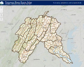
Potomac River Basin AtlasThis map features the subbasins (HUC 8), watersheds (HUC10), and subwatersheds (HUC12) of the Potomac River basin. Users can toggle among layers to learn more about the watershed. |
 |
Wandering the WatershedThis StoryMap features the About the Basin articles on places of interest throughout the basin. The articles are written for ICPRB’s weekly Riverwatch newsletter during the summer. |
 |
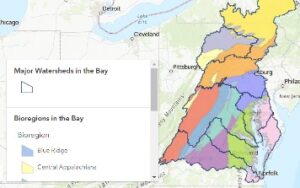
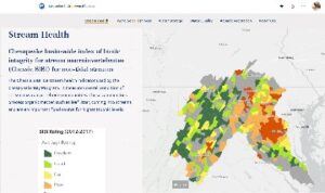
Bioregions of the Chesapeake BayThis map explores the twelve bioregions of the Chesapeake Bay watershed as they relate to stream macroinvertebrates which include insect larvae, snails, and water beetles. It is part of ICPRB’s Chessie BIBI Index for Stream Health project. |
 |
Potomac Basin Water Resources Comp PlanThis StoryMap features the wide array projects and products that were completed based on recommendations in the Potomac River Basin Water Resources Comprehensive Plan. |
 |
A Deep Dive into Potomac River HistoryA StoryMap that explores people, organizations, and events that make the Potomac River what it is today and what it will become. |
 |
Watershed Group DirectoryThis map features many of the watershed groups within the basin to encourage engagement and stewardship from the public. |
 |
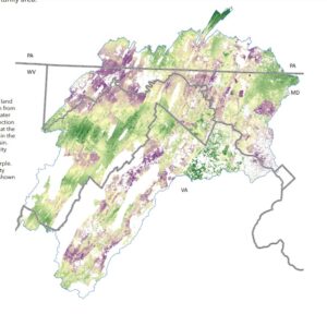
Land Prioritization Story MapThis StoryMap explores the Land Prioritization Mapping Project which aims to assist land conservation organizations in prioritizing specific parcels of land in the Potomac River basin to obtain the most drinking water quality benefits. |
 |
Tracking Environmental ProgressThis StoryMap is intended for the 2023 Advisory Committee for the Potomac River Basin Water Resources Comprehensive Plan five-year review process. It showcases maps with data that could be used for metric development to track environmental progress. |
 |
Will Runoff Alter your Streamflow?This map looks at streamflow alteration from impervious cover. We know very small amounts of impervious cover — less than 2% of watershed cover — can impact local streamflow. This site maps the characteristics that make a stream more or less susceptible to flow impacts from impervious cover. These characteristics include watershed area, karst geology, precipitation, soil characteristics, physiographic province, and slope. |
|