A PDF of PRESS RELEASE “Good News for the Bay” is available here.
New data shows an improvement in stream health across the Chesapeake Bay watershed.
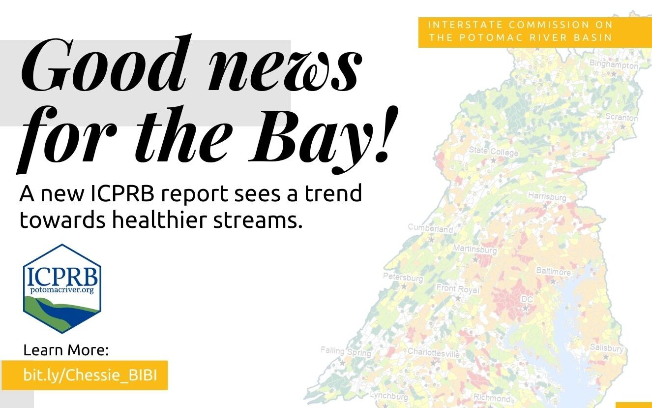
 A popular song in the hit Broadway show, Rent, asks how to measure a year. In minutes? In moments? A recent report from the Interstate Commission on the Potomac River Basin (ICPRB) explores how scientists can measure stream health. By macroinvertebrates? By miles? The experts at the Chesapeake Bay Program think so. Chessie BIBI, a data-tracking tool used to calculate the health of small- to medium-sized streams, suggests a roughly 6 percent improvement in stream health in the Bay watershed.
The Chesapeake Basin-wide Index of Biotic Integrity, known in the water-world as Chessie BIBI, is a multi-metric index calculated from the numbers and types of small animals, called macroinvertebrates, that live in free-flowing (non-tidal) streams of the Bay watershed. The index relies on data collected by state, federal, county, and volunteer monitoring programs to track the number of “healthy” stream miles in the region from year to year. Chessie BIBI is a long-term ICPRB evaluation that provides water quality assessment for the Potomac basin and the Chesapeake Bay watershed.
As Dr. Claire Buchanan, co-author of the report and Emerita Director of Program Operations at ICPRB, explains,
“You can tell a lot about the health of a stream by what lives at the bottom. A quality stream has an abundance of life and many species from across the food web. You won’t see that in an unhealthy stream.”
To capture the full picture over a longer period, Chessie BIBI tracked three 6-year time periods between 2000 and 2017. The time periods were designated pre-baseline, baseline, and first interval. The baseline period is from the 2014 Chesapeake Bay Agreement which established a stream health goal to, “Improve health and function of ten percent of stream miles above the 2008 baseline for the watershed.” This report compared the healthy stream miles from the baseline period (2006 – 2011) to the first interval period (2012 – 2017) and found that the number of healthy stream miles went from 61.7 percent to 67.8 percent, respectively.
According to the report, there are many ways to measure stream health. Chessie BIBI is just one of them, but it is a good overall indication of stream health across the Bay watershed. Dr. Buchanan says that Chessie BIBI can be used as a management tool to track progress across jurisdictional boundaries and towards the goals set out in the Bay Agreement.
“Improvement is not happening across the board, but the overall picture is positive. We are excited about the trajectory and hope to see the trend continue as we examine successive 6-year periods in the future. We are currently collecting data for the next 6-year period of 2018 – 2023,” says Dr. Buchanan.
The report does not point to a specific reason for increased stream health but suggests a combination of stressors are now probably low or abating, allowing an overall improvement in the Chessie BIBI index in undisturbed streams.
According to the report, studies have linked poor stream health with altered stream flows, excessive nutrients and sediment, urban landcover, acid deposition and mine drainage, and climate change.
More information and a copy of the report, Stream Biological Health in the Chesapeake Bay Watershed, can be found on ICPRB’s “Chessie BIBI” Index for Streams page, including an interactive map of the findings, as well as an interactive map of the 12 bioregions of the Chesapeake Bay.
Contact
Renee Bourassa, Outreach Program Manager
Interstate Commission on the Potomac River Basin
rbourassa@icprb.org | 301.417.4371 | ICPRB
Interactive Map of Chessie BIBI
The ICPRB is an interstate compact commission established by Congress in 1940. Its mission is to protect and enhance the waters and related resources of the Potomac River basin through science, regional cooperation, and education. Represented by appointed commissioners, the ICPRB includes the District of Columbia, Maryland, Pennsylvania, Virginia, West Virginia, and the federal government.