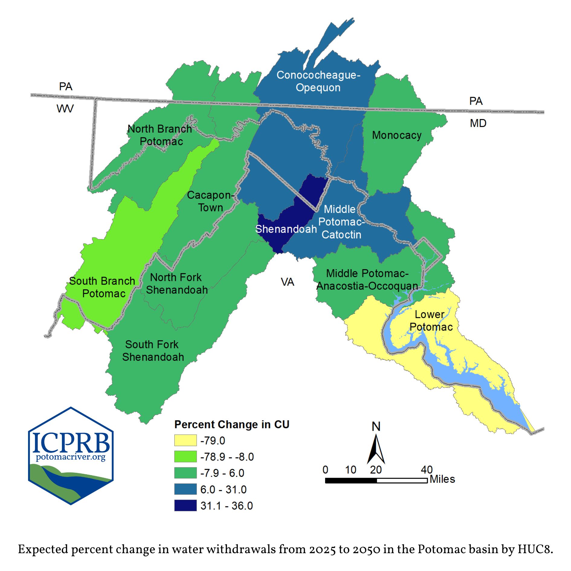
A newly published pamphlet, Potomac Basin Trends in Water Use, summarizes forecasted reported water withdrawals and consumptive use in the Potomac basin. Understanding current and anticipated water use is vital for sustainable water resources planning today and into the future. Consumptive Use (CU) is the portion of water withdrawn from a resource and not returned for subsequent use. Examples of CU: evaporated irrigation and cooling water, bottled drinking water, and water consumed by people or livestock.
ICPRB Report Explores Future Water Use Across the Watershed
A newly published pamphlet, Potomac Basin Trends in Water Use, summarizes forecasted reported water withdrawals and consumptive use in the Potomac basin. Understanding current and anticipated water use is vital for sustainable water resources planning today and into the future.
The D.C. Department of Energy and Environment’s (DOEE) Fisheries Research Branch is conducting their annual creel survey and encourages local anglers to participate. The goal of the survey is to better understand recreational angling efforts, perceptions, and harvests within Washington D.C. The information obtained from the voluntary survey will be used to inform fisheries management decisions and regulations. DOEE encourages anglers to fill out the form after every fishing trip.
The Interstate Commission on the Potomac River Basin (ICPRB) recently published an update to a comprehensive planning document that it hopes will be used as a tool to protect water supplies, drinking water sources, water quality, and aquatic life.
At this week’s ICPRB Quarterly Business Meeting, the ICPRB Commissioners formally adopted the 2023 Updates to the Potomac Basin Comprehensive Water Resources Plan. The document is the result of a yearlong stakeholder process that evaluated progress during the first five years of implementation and developed the workplan for the next five years.
A section of the report includes how the public can get involved:
Encourage and participate in stewardship activities that improve watershed conditions, such as trash pickups, reducing winter salt use, and picking up pet waste.
Share the plan with local politicians, water suppliers, environmental organizations, and civic organizations.
Federal Funding to Protect and Preserve the Potomac River Watershed
ICPRB received $650,000 in the recent funding package passed by Congress.
In making the announcement, ICPRB Executive Director Michael Nardolilli stated, “We are glad to see the federal government acknowledge the important work of the Interstate Commission on the Potomac River.”
The Interstate Commission on the Potomac River Basin (ICPRB) will use this as a tool to protect water supplies, drinking water sources, water quality, and aquatic life, and encourages other organizations to do the same.
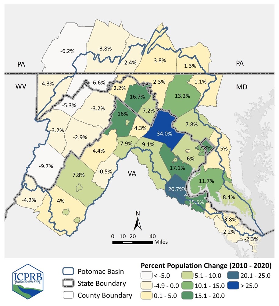
Population changes in the Potomac River watershed (2010-2020).
“The Potomac River watershed is home to 6.9 million people. As the saying goes, we all live downstream. Practices and policies throughout the watershed impact our waterways. We expect this updated plan to continue to serve as a catalyst for sustainable water resources management throughout the watershed,” explains Michael Nardolilli, Executive Director of ICPRB.
The plan addresses water resources challenges to the watershed, including sustainable water uses and supplies, protecting and improving water quality, sustainably managing human land use, and protecting ecological health.
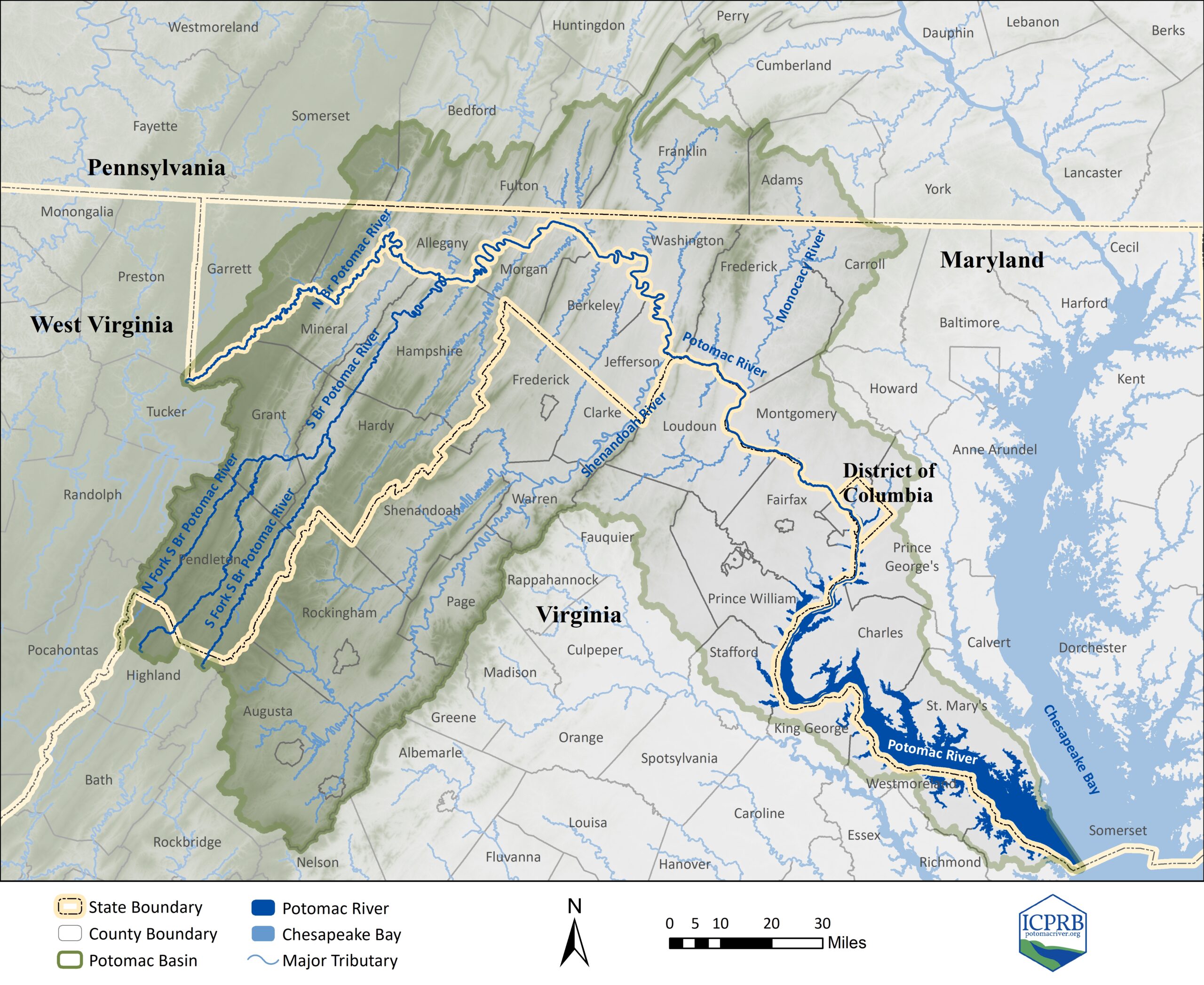
The Potomac River watershed includes parts of Virginia, Maryland, West Virginia, and Pennsylvania, as well as the entire District of Columbia. According to Nardolilli, most of the residents in the watershed rely on the Potomac River or its tributaries for drinking water.
The planning document, titled Potomac Basin Comprehensive Water Resources Plan, was originally published in 2018. The 2023 updates were the result of a yearlong review process by an advisory committee composed of regional governments, nonprofit organizations, and academic institutions. It was officially adopted by the ICPRB Commissioners at the business meeting on March 12, 2024.
“The population in the Potomac River watershed has increased by 13% since 2010. With this immense growth, it is more important than ever that we practice smart and sustainable water resources planning. We think this Comprehensive Plan is the tool to achieve that vision,” says Nardolilli.
According to Nardolilli, milestones from the initial 2018 plan are mostly complete. New goals developed in the recent update are expected to begin in the spring of this year.
“It takes a watershed-wide effort to protect and preserve the Potomac River and its related resources. Through a diverse stakeholder group, the plan provides a voice for people and organizations throughout the basin. Further, the update highlights the need to reach the wonderfully varied communities of the basin, with particular focus on those disproportionately affected by water resources issues,” states Dr. Heidi Moltz, Director of Program Operations at ICPRB and an author of the plan.
Dr. Moltz shares some of the ways the public can get involved which are suggested in the new report:
Encourage and participate in stewardship activities that improve watershed conditions, such as trash pickups, reducing winter salt use, and picking up pet waste.
Share the plan with local politicians, water suppliers, environmental organizations, and civic organizations.
Renee Bourassa, Communications Director
Interstate Commission on the Potomac River Basin | Rockville, MD rbourassa@icprb.org | 301.417.4371 | ICPRB
The 2023 Updates to the Potomac River Basin Comprehensive Plan can be found on ICPRB’s website at: https://bit.ly/basin_plan
The ICPRB is an interstate compact commission established by Congress in 1940. Its mission is to protect and enhance the waters and related resources of the Potomac River basin through science, regional cooperation, and education. Represented by appointed commissioners, the ICPRB includes the District of Columbia, Maryland, Pennsylvania, Virginia, West Virginia, and the federal government. The ICPRB affirms the importance of fostering diversity equity, inclusion, and justice in all activities. The Potomac belongs to all.
Authorized by an Act of Congress in 1940, the mission of the Interstate Commission on the Potomac River Basin (ICPRB) is to protect and enhance the waters and related resources of the Potomac River basin through science, regional cooperation, and education.
Map of the Potomac River watershed
When the Interstate Compact was approved in 1940, Congress stipulated that ICPRB shall be provided annual appropriations from the United States. According to the executive director, other than in 2009, ICPRB has not received federal appropriations since 1996.
In making the announcement, ICPRB Executive Director Michael Nardolilli stated, “We are glad to see the federal government acknowledge the important work of the Interstate Commission on the Potomac River. We are very appreciative of the work done by Congressman Raskin and Senators Cardin, Casey, and Van Hollen and their Staffs.”
According to Nardolilli, ICPRB plans to use the funds to improve water modeling capabilities and implement the 2018 Potomac River Basin Comprehensive Water Resources Plan. The 2023 updates to this plan are being considered by the ICPRB Commissioners later this week.
Work plans include:
Enhance emergency spill modeling tools to help protect water supply intakes from spills into the river of oil and other chemical contaminants.
Investigate feasibility, collect data, and construct eelways on the Potomac River.
Collect bathymetric LiDAR data for the Potomac River North Branch to support 3D flow modeling.
Develop better modeling capabilities for drinking water reservoir management.
Host a series of webinars to promote sustainable water resources management.
Advance the use of ICPRB’s impervious cover tool to assist decision-makers in understanding the relative effects of proposed impervious cover sites on local hydrology.
###
FOR IMMEDIATE RELEASE – March 11, 2024
Renee Bourassa, Communications Director
Interstate Commission on the Potomac River Basin | Rockville, MD rbourassa@icprb.org | 301.417.4371 | ICPRB
More information about ICPRB can be found on their website at www.potomacriver.org.
The ICPRB is an interstate compact commission established by Congress in 1940. Its mission is to protect and enhance the waters and related resources of the Potomac River basin through science, regional cooperation, and education. Represented by appointed commissioners, ICPRB includes the District of Columbia, Maryland, Pennsylvania, Virginia, West Virginia, and the federal government. ICPRB affirms the importance of fostering diversity equity, inclusion, and justice in all activities. The Potomac belongs to all.
Dr. Birthe V. Kjellerup is the newest commissioner representing the state of Maryland for the Interstate Commission on the Potomac River Basin (ICPRB). She is an associate professor at the University of Maryland at College Park at the A. James Clark School of Engineering where she also serves as the Chair for Diversity, Equity, and Inclusion,
“We welcome Dr. Kjellerup to ICPRB and are happy to have her as a commissioner. I look forward to working with her to address pollution and water supply challenges of the Potomac River,” stated Michael Nardolilii, Executive Director of ICPRB. The ICPRB Commission is composed of three commissioners and three alternate commissioners from the District of Columbia, Maryland, Pennsylvania, Virginia, West Virginia, and the Federal Government.
March 28 – Walk in the Woods: Potomac Marble (Dickerson, MD) – Join the first guided hike of 2024 to hear author Paul Kreingold and historian Jon Wolz talk about geology, history, and the search for the stone that was used to rebuild D.C. after the 1814 British invasion.
April 28 – Walk in the Woods: Frederick Municipal Forest (Frederick, MD) – A spring guided hike with Jenny Willoughby, Sustainably Manager for the City of Frederick. We will discuss protecting and managing the Frederick Municipal Forest (w/ some plant ID in the mix).
May 18 – Walk in the Woods: Flexing Mussels with Anacostia Watershed Society (DC) – Registration coming soon!
October 12 – Walk in the Woods: Let’s be Smart About Winter Salt (Gaithersburg, MD) – A beautiful fall walk & talk to discover the hidden impact of winter salt use and what we all can do to protect our waterways.
October 19 – Walk in the Woods: Strawberry Hill Preserve (Fairfield, PA) – Explore the streams meandering through the Strawberry Hill property and gain insights into their critical role in maintaining the health of the waters
We’ll be adding more fun and informative events throughout the year. We also plan to bring our creek critter meet and greet to the Earth Day Celebration (April 20, Frederick, MD), Anacostia River Festival (May 4, DC), Festival del Rio Anacostia (September 21, DC), and many more! Stay tuned by checking out ICPRB Events on our website.
ICPRB Q2 Business Meeting will be on March 12, 2024
ICPRB will hold the second quarter business meeting on Tuesday, March 12, 2024. Commissioners will learn about computer models used to predict water quality endpoints and discuss the adoption of the 2023 updates to the Potomac Basin Comprehensive Water Resources Plan. The public is invited to view the virtual meeting. Please respond to this email for more information on how to attend.
Correction Notice
Editor’s Note: Last week’s newsletter included the news article Virginia Introduces Amended Virginia Pollutant Discharge Elimination System Permit to Protect Chesapeake Bay. We were subsequently informed that information found in the article is not accurate. We regret the error.
The ICPRB will hold its second quarter business meeting on Tuesday, March 12, 2024. The meeting will be held virtually on Teams. Commissioners will learn about computer models used to predict water quality endpoints and have a chance to adopt the 2023 Updates to the Potomac Basin Comprehensive Water Resources Plan. Find the draft agenda on our Business Meetings site.
The public is invited to view the virtual meeting. Please contact us for more information on how to attend.
Last Thursday, ICPRB staff briefed lawmakers and their staff on Capitol Hill about the issues facing the Potomac basin and the work we do to protect and preserve its waters. They joined the experts from our two sister Mid-Atlantic river basin commissions, the Delaware River Basin Commission and the Susquehanna River Basin Commission. ICPRB’s aquatic biologist, Mike Selckmann, presented on his team’s research on harmful algal blooms.
ICPRB staff also met with elected leaders and their representatives to discuss federal funding for a study to make the DC Metro area water supply more resilient. In addition, ICPRB staff requested that the federal government carry out it’s statutory commitment to the organization.
ICPRB staff and commissioners shared their #PotomacLove
Last week, ICPRB staff, commissioners and our partners shared photos and sentiments about why they love the Potomac River. Check out the video of ICPRB posts or click on your preferred social media platform below to see all the #PotomacLove posts. We would love to hear why you love the Potomac River!
Newsletter Subscription
Stay informed about the latest news, impactful projects, environmental challenges, and community initiatives in the Potomac River watershed—sign up today!