
Volume I Stressor Analysis Report for the Benthic Macroinvertebrate Impairments in the Accotink Creek Watershed, Fairfax County, Virginia
Prepared by ICPRB for Virginia Department of Environmental Quality (DEQ).
Prepared by ICPRB for Virginia Department of Environmental Quality (DEQ).
Prepared by ICPRB for Virginia Department of Environmental Quality (DEQ).
Prepared by ICPRB for Virginia Department of Environmental Quality (DEQ).
The Virginia Department of Health issued a Harmful Algae Bloom (HAB) Advisory for a 53-mile stretch of the North Fork of the Shenandoah River on August 10, 2021 (Figure 1, left). Samples from multi-species algal mats on the river bottom contained harmful levels of toxins produced by cyanobacteria. Three weeks later, Tropical Storm Ida passed over the North Fork, dumping torrential rain on the watershed. Sharply rising streamflows were expected to scour the benthic algal mats, potentially lysing their cells and releasing toxins as they washed downstream. The ICPRB’s Emergency River Spill Model (ERSM) indicated the scoured material’s leading edge would reach the Potomac River mainstem by September 2nd – 4th and Great Falls near Washington, D. C. by September 3rd – 6th.
Virginia Department of Environmental Quality staff confirmed the algal mats were scoured off the river bottom. Water samples collected by ICPRB at the Shenandoah River mouth indicate the storm’s high flows diluted the algal cells and their associated toxins to below-detection levels before they reached the Potomac River. If flows had been less intense, we hypothesize the scoured material and toxins could potentially have reached the Potomac River mainstem. More advanced flow modeling and additional sampling during algal blooms could better characterize the potential transport of scoured or senescing algal blooms in the Shenandoah River under different river conditions.
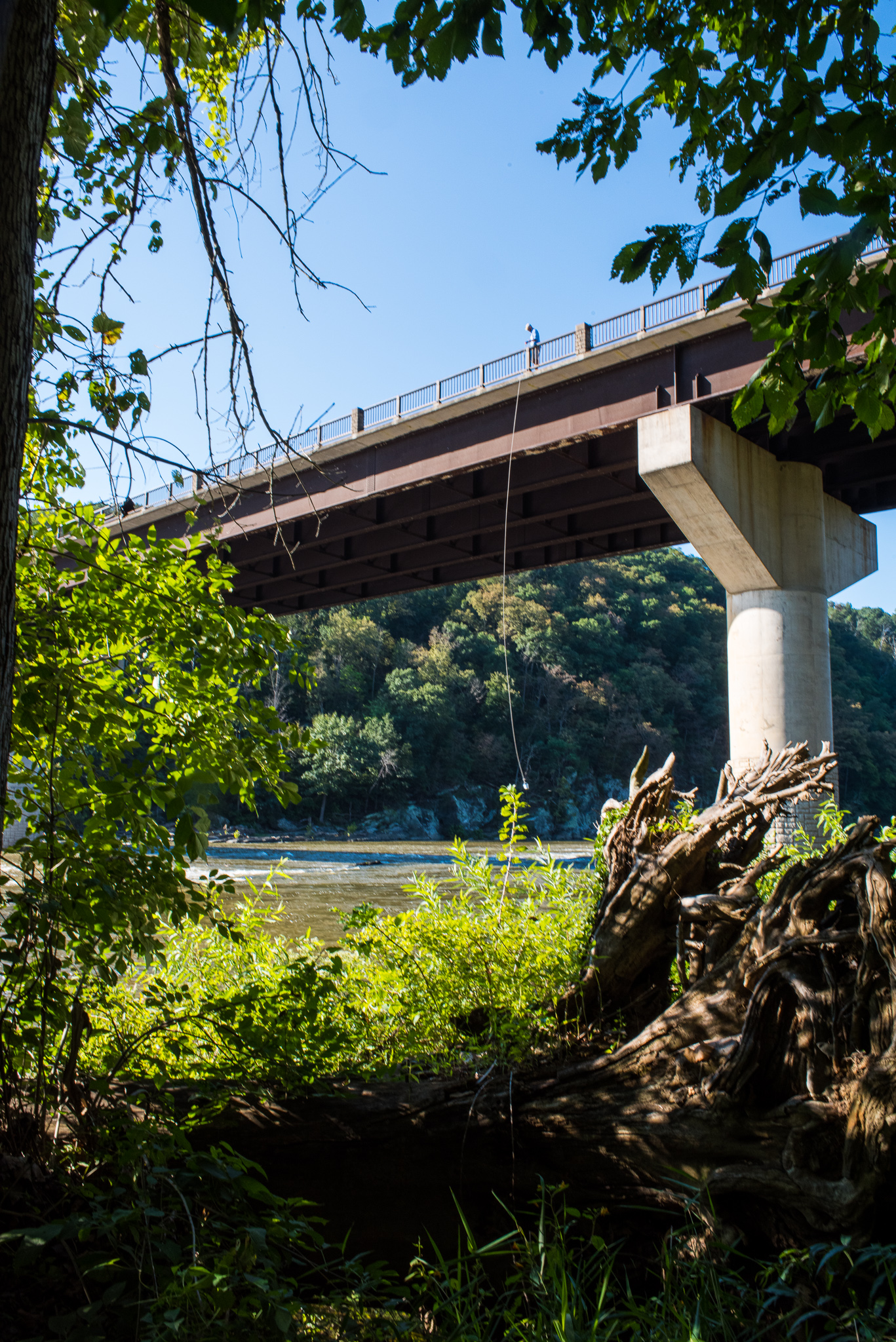
Rt. 340 bridge over Shenandoah River near Harpers Ferry, WV
The Interstate Commission on the Potomac River Basin (ICPRB) and the Center for Watershed Protection (CWP) conducted a pilot study of water quality data collected at Moores Run in Baltimore City, Airpark Business Center in Carroll County, and Urbana in Frederick County to characterize stormwater discharges and evaluate watershed restoration activities. The overarching objectives were to determine if there are trends in water quality over time and, if any trends are found, attempt to relate them to watershed restoration efforts or the implementation of Best Management Practices (BMPs). Another goal of the pilot study was to provide recommendations for future analysis of MS4 monitoring data and improving the monitoring requirements in Maryland’s Phase I MS4 permits.
Tables and figures are available here.
Understanding the temporal and spatial roles of nutrient limitation on phytoplankton growth is necessary for developing successful management strategies. Chesapeake Bay has well-documented seasonal and spatial variations in nutrient limitation, but it remains unknown whether these patterns of nutrient limitation have changed in response to nutrient management efforts. We analyzed historical data from nutrient bioassay experiments (1992–2002) and data from long-term, fixed-site water-quality monitoring program (1990–2017) to develop empirical approaches for predicting nutrient limitation in the surface waters of the mainstem Bay. Results from classification and regression trees (CART) matched the seasonal and spatial patterns of bioassay-based nutrient limitation in the 1992–2002 period much better than two simpler, non-statistical approaches. An ensemble approach of three selected CART models satisfactorily reproduced the bioassay-based results (classification rate = 99%). This empirical approach can be used to characterize nutrient limitation from long-term water-quality monitoring data on much broader geographic and temporal scales than would be feasible using bioassays, providing a new tool for informing water-quality management. Results from our application of the approach to 21 tidal monitoring stations for the period of 2007–2017 showed modest changes in nutrient limitation patterns, with expanded areas of nitrogen-limitation and contracted areas of nutrient saturation (i.e., not limited by nitrogen or phosphorus). These changes imply that long-term reductions in nitrogen load have led to expanded areas with nutrient-limited phytoplankton growth in the Bay, reflecting long-term water-quality improvements in the context of nutrient enrichment. However, nutrient limitation patterns remain unchanged in the majority of the mainstem, suggesting that nutrient loads should be further reduced to achieve a less nutrient-saturated ecosystem.
Published in the Journal of Water Research, Volume 188, January 2021:
https://doi.org/10.1016/j.watres.2020.116407
The watershed of the North Branch Potomac River experienced severe environmental degradation and flooding in the 20th century. A dam across the river mainstem was completed in 1982, creating Jennings Randolph Lake. The lake and dam are operated by the U. S. Army Corps of Engineers for four authorized purposes: control floods, dilute downstream pollution, supply drinking to Washington DC during droughts, and provide recreation. Water quality in the North Branch watershed has improved considerably since the dam was built due to many factors, including regulatory enforcement, mine runoff mitigation, wastewater treatment, infrastructure improvements, forest regrowth and the abatement of acid rain (see ICPRB report 19-4). This pilot study was done to determine if an update of the 1997 Reservoir Regulation manual is appropriate at this time. The report reviews and evaluates each of the authorized purposes in terms of their original management goals and objectives, current relevance, and future application.
A copy of the report is available here.
Riparian buffers are an important conservation practice to mitigate water quality degradation in the Coastal Plain of the Chesapeake Bay watershed (CBW). Although forested and grassed riparian buffers have been implemented in this region through government programs, the impacts of riparian buffers on water quality have been rarely examined. The objective of this study was to assess the long-term effects of riparian buffers to improve water quality in the Coastal Plain of the CBW. A watershed model, Soil and Water Assessment Tool (SWAT), was employed for this study. Considering impacts of model uncertainty (i.e., equifinality) on the effectiveness of riparian buffers, we adopted all parameter sets that produced acceptable simulation results. Multiple riparian buffer implementation scenarios were developed to generate the baseline condition on total organic nitrogen (TON) loads without riparian buffers and examine variation of TON loads with areal coverage of riparian buffers. Through the calibration processes, a total of 235 acceptable parameter sets were identified and used to simulate TON loads. The simulation results indicated that riparian buffers significantly reduce TON loads. Without riparian buffers, annual TON loads from the 220 km2 study watershed were 18 to 34 metric tons, but declined to 8 to 21 metric tons with riparian buffers. The effectiveness of riparian buffers on reducing annual TON loads increased from 17% to 45% with an increase in the extent of riparian buffer implementation. The effectiveness of riparian buffers tended to be higher during early spring than other seasons as high soil water conditions promote occurrence of surface water flow and thus TON loads. Riparian buffers were more efficient on croplands than other land use types due to high soil nutrient levels caused by fertilizer applications. The effectiveness of riparian buffers differed considerably by parameter set. Thus, efforts to consider model uncertainty are important to provide better insight into the impacts of conservation practices. This study supports ongoing riparian buffer programs for the Mid-Atlantic Coastal Plain by demonstrating the effectiveness of riparian buffers and informing implementation guidelines.
Published in the Journal of Hydrology, Volume 585, June 2020: https://doi.org/10.1016/j.jhydrol.2020.124779
Land‐use and climate change are significantly affecting stream ecosystems, yet understanding of their long‐term impacts is hindered by the few studies that have simultaneously investigated their interaction and high variability among future projections. We modeled possible effects of a suite of 2030, 2060, and 2090 land‐use and climate scenarios on the condition of 70,772 small streams in the Chesapeake Bay watershed, United States. The Chesapeake Basin‐wide Index of Biotic Integrity, a benthic macroinvertebrate multimetric index, was used to represent stream condition. Land‐use scenarios included four Special Report on Emissions Scenarios (A1B, A2, B1, and B2) representing a range of potential landscape futures. Future climate scenarios included quartiles of future climate changes from downscaled Coupled Model Intercomparison Project ‐ Phase 5 (CMIP5) and a watershed‐wide uniform scenario (Lynch2016). We employed random forests analysis to model individual and combined effects of land‐use and climate change on stream conditions. Individual scenarios suggest that by 2090, watershed‐wide conditions may exhibit anywhere from large degradations (e.g., scenarios A1B, A2, and the CMIP5 25th percentile) to small degradations (e.g., scenarios B1, B2, and Lynch2016). Combined land‐use and climate change scenarios highlighted their interaction and predicted, by 2090, watershed‐wide degradation in 16.2% (A2 CMIP5 25th percentile) to 1.0% (B2 Lynch2016) of stream kilometers. A goal for the Chesapeake Bay watershed is to restore 10% of stream kilometers over a 2008 baseline; our results suggest meeting and sustaining this goal until 2090 may require improvement in 11.0%–26.2% of stream kilometers, dependent on land‐use and climate scenario. These results highlight inherent variability among scenarios and the resultant uncertainty of predicted conditions, which reinforces the need to incorporate multiple scenarios of both land‐use (e.g., development, agriculture, etc.) and climate change in future studies to encapsulate the range of potential future conditions. DOI link: https://doi.org/10.1111/gcb.14961
The report was published in the September 2018 edition of the Journal of Hydrologic Engineering.
Stay informed about the latest news, impactful projects, environmental challenges, and community initiatives in the Potomac River watershed—sign up today!